TOPOGRAPHICAL SURVEY SERVICES IN KENYA AND AFRICA
A Topographical Survey is an accurate depiction of an object, a feature or site (e.g. property, area of land or a defined boundary) which is scaled and detailed according to the spatial considerations (coordinates, bearings, distances etc.) and is the summary of the on-site data capture processes. Topographical survey determines the location of natural and man-made features (such as buildings, improvements, fences, land contours, trees, streams, etc.) of the land along with its elevations. Topographic survey provides you with the exact figures of the size, height, position of the different changes that have occurred in course of time with regard to their presence of their natural existence. Sometimes, these surveys are also used for the formulation of an optimal plan for drainage, ditches, grading and other features. A Topographic Map is used to depict terrain relief showing ground elevation, usually through either contour lines or spot elevations.
Requirements for Topographical Surveys
- Geodetic or 1:50,000 topo maps showing the Ground Control Points, Benchmarks or spot heights as established by Survey of Kenya etc;
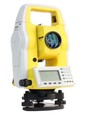
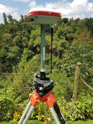
- High precison and calibrated survey equipment e.g. a total station, level machine, drone or a GNSS (RTK or geodetic);
- A CAD Drafting software such as AutoCAD Civil 3D or Spatial analysis software e.g. ArcGIS or QGIS;
- A registered Surveyor (from Institution of Surveyors of Kenya-ISK) or a licensed Surveyor (from Licensed Surveyors Board-LSB);
- Some projects may require bush clearing done prior to executing topo survey work. This is important to ensure there is no obstruction during survey work.
Methods for Topographical Surveys
- Geographical Information Systems (GIS): GIS has contributed a lot to the mapping revolution in 21st century. GIS makes it possible to combine layers of digital data from different sources and to manipulate and analyze how the different layers relate to each other. The process of converting 3D topographic maps to digital form involves raster to vector conversion using CAD-based software such as AutoCAD.
- Total Station or Theodolite Surveys: The total ststion or theodolite measures the angles, and the distances are measured with either a steel measuring tape or, more commonly, an electronic distance meter (EDM). An EDM can measure great distances (several kilometres) very quickly and accurately. It measures distance with the usage of light and radio waves. Its development was a milestone in survey measurement methods.
- GNSS or GPS: A constellation of Global Navigation Satellite System (GNSS) or Global Positioning System (GPS) satellites orbiting the earth is used to determine the position(s) of GPS ground receivers as they are moved from one point to another. The collected data may either be processed in the office to produce GPS receiver positions (control surveys) or in the field to give the field surveyor immediate receiver positions (real time GPS surveys) for use for example in construction or for subdivision layout surveys.
- LiDAR Technology: Airborne LIDAR (Light Detection And Ranging) systems can produce extremely accurate elevation models for terrain (even measuring ground elevation through trees), while offering a quick and efficient method of surveying terrain that is not easily accessible. LiDAR, like the similar radar technology (which uses radio waves instead of light), determines the range to an object by measuring the time delay between transmission of a pulse and detection of the reflected signal.
- Photogrammetry: In this method, stereographic pairs of photographs are used to indirectly measure objects on the ground and then calculate point coordinates and height differences.
- UAV or Drone Technology: Unmanned Aerial Vehicles popularly known as drones have become one of the greatest innovations in aerial mapping realm. Drones can be used to execute topographical surveys at varying accuracies. Drones fly at height of approximately 100 to 150 metres above the ground level capturing images at a resolution of 3cm. The images can then be processed to create DSMs, DEMs and topographical maps with contours.
Procedure for Topographical Survey Work
- The first step is plan and carry out a reconnaissance or pre-visit to the project site to get acquinted with the general landcape of the site, location where the secondary controls will be established and whether bush clearing is required.
- Once an ideal location has been identified, the establishment of both horizontal (x,y) and vertical (z) ground control points is done and coordinates precisely observed using Static Survey method.
- The observed static coordinates are then post-processed & survey adjustment done to ensure that GNSS observation errors are eliminated. This is often done using a PC software e.g. EZSURV for performing a survey network adjustment by least squares.
- Once the horizontal and vertical control points have been established, readings are made from a total station or geodetic GPS (RTK) placed on the known points. The readings on features within the project area (e.g. edge of road, fence, corner of building, tree etc) are picked in 3D format i.e. X, Y and Z.
- Topographical survey is often carried out by recording the coordinates of features using GNSS i.e. base (known GCP) and rover configuration. The data logger with field software e.g Field genius records and stores the coordinates.
- Sometimes the primary control points my be close to the project area. In such a case, a simple closed traverse between two known controls can be done using equipment such as a theodolite or a total station to establish the other secondary control points to be utilized in conducting a topo survey.
- If the topographical survey is to be executed using a total station (TS), then the location of known control points must have a clear line of sight for orientation purposes whilst computing the join. Survey using a total station may take longer time as compared to the GNSS. Just use the right equipment for the right job.
- Upon completion of field survey work, the data is downloaded back in office, analysed and processed using a software such as AutoCAD Civil 3D to generate contours, Digital Terrain Model (DTM), Digital Elevation Model (DEM), Cross-section and longitudinal profiles as well the topographical map.
- When preparing the topographical map it is important to consider the contour interval to adopt as well as the map scale. These parameters often vary depending the the requirements and specifications from the client. One GNSS base can also serve many rovers!
Topographical Survey Outputs or Products
- Field Survey Observation data showing observed coordinates and their accuracy e.g. in excel or a spreadsheet;
- A topographical map drawn to scale e.g. 1:500 or 1,1000 or 1,2500 depending on the client need;
- Longitudinal and cross sectional profiles for further engineering design work e.g. sewerline or pipeline laying out;
- A fieldwork and data processing report indicating the overall approach adopted during fieldwork and data analysi;
- Other information such as field photos, accuracy sheet, survey adjustment computations incase of Static Survey etc.
