Drone Survey & Mapping
Unmanned Aerial Vehicles (UAVs) popularly known as Drones have become proven technology in the sphere of Aerial Mapping and Survey. Our Licensed Pilots by KCAA, use Drones or UAVs as well aerial mapping/survey services which are increasingly becoming the go-to solution for many Geospatial professionals and industries. At Orbital Africa, we're at forefront in employing latest drone/UAV technology incorporating SenseFly hardware (drones) and Pix4D software products. Below is a simple workflow of Drone Images/Big Data processing. At Orbital Africa, we also offer Training on Drone/UAV/UAS Mapping encompassing flight planning, flying the drone, data download and processing using software such as Pix4D, Agisoft, Drone Deploy etc.
Flight Plans
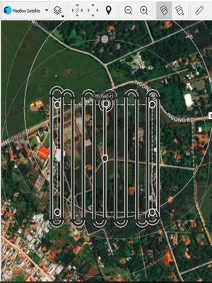
1: Selecting area to be mapped and can be done using the eMotion and DroneDeploy.
DETAILS...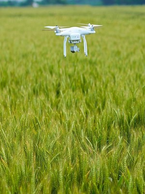
Drone Survey
2: Drone or UAV is launched after flight planning to fly and capture the images within AoI defined.
DETAILS...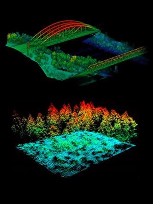
Data Process
3: Employs Pix4D, DroneDeploy & Agisoft among other software to process drone images.
DETAILS...Orbital Africa is the leading Drone, UAV, UAS Mapping and Training Company based in Kenya with branches in Ethiopia, Tanzania, Uganda, south Sudan, Rwanda, Botswana and Africa at large.. We employ a number of best drones e.g. DJI Phantom 4 RTK, eBee SenseFly from various manufacturers across the globe. Several software available in the market for processing drone images and creating orthomosaics and Digital Surface Models (DSMs), Digital Elevation Models (DEMs) etc. include Pix4D, Agisoft among others. Drones for mapping normally fly at an altitude of 100 metres to 300 metres.

Notably, the spatial resolution of the drone images decreases considerably with increase in altitude but the drone is capable of capturing large image scenes. With the drones, one can obtain an image of up to 2cm Spatial Resolution! We also hire, rent or lease all types of drones at affordable rates.
At Orbital we use various drones such as DJI Phantom 4 RTK, eBee X and SQ. The eBee SQ is an advanced Agricultural Drone that takes professionals such as crop consultants, growers and researchers from drone to action, simply and efficiently. The eBee SQ can fly for up to 55 minutes on a single battery charge. This performance enables it to cover up to 500 acres in a single flight at 120 Metres above ground level - up to 10 times more ground than small quadcopter drones - for extremely efficient crop monitoring and analysis. The result is fewer flights per project, for less time spent collecting field data and more time acting on it e.g. analysis and processing. Also read more about LiDAR UAVs and Thermal Imaging UAVs as well as Drone Mapping and Image Processing Workflows.
Arguably, using Drones will lead to a large increase in the amount of physical data being collected, this does mean an increase in office time spent processing and utilizing this data. However, this expansion is canceled out many times over by the huge time savings a drone produces out in the field. Many of senseFly’s surveying customers say, for example, that large jobs that once took weeks can now be completed in just a few days, and that a week’s worth of traditional data collection is now achieved in just one day. Last but not least, less time spent on the ground means staff safety is improved by minimizing risk to surveying teams when measuring sites such as mines, unstable slopes and transport routes. Simply choose take-off and landing locations that are out of harm’s way.
Orbital Africa has successfully carried out many Drone/UAV Mapping projects in Kenya and Africa region at large. Recently, we conducted drone mapping project in a 17-acre parcel of land in Kiambu County. The outputs of the project was a 3cm resolution Orthomosaic, a DEM, DSM and Contours. The sample Orthomosaic can be viewed here: >>Kiambu Drone Project.
Photo Gallery
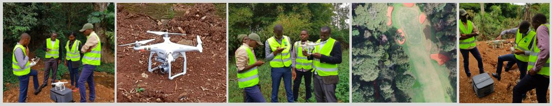
Here, you can view More Photos.. of the project.
Drone regulations and use in Kenya has been intricate for quite sometime now. Apparently, from the latest developments, it appears like the government has flexed its muscles on UAV ownership and operations in Kenya. So, The government of Kenya has approved the Drone Ownership and Operations.
When choosing a right drone for a particular assignment, one of the first questions that you must ask yourself is whether you need a multi-rotor or fixed wing drone. Both multi-rotor and fixed wing drones have a niche of pros and cons that make them better suited for specific uses, so it’s imperative to comprehend the key differences between both types before acquiring one. Therefore, before purchasing a drone, you need to consider some of the following factors: Comparing a Fixed-wing and a Multi-rotor Drone
Unmanned Aerial Vehicles (UAVs) popularly known as Drones have become proven technology in the sphere of Aerial Mapping and Survey. These are some of the Drone/UAV companies operating in Kenya and Africa at large: Drone and UAV Companies in Kenya