CC302 - GIS for Mining and Geological Mapping Course
Introduction
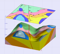 Remote sensing and GIS have played an important role in the study of mineralized areas. A review on application of remote sensing in mineral resource and geological mapping will be covered. It involves understanding the application of remote sensing in lithologic, structural and alteration mapping. Remote sensing becomes an important tool for locating mineral deposits, in its own right, when the primary and secondary processes of mineralization result in the formation of spectral anomalies. Reconnaissance lithologic mapping is usually the first step of mineral resource mapping. This is complimented with structural mapping, as mineral deposits usually occur along or adjacent to geologic structures, and alteration mapping, as mineral deposits are commonly associated with hydrothermal alteration of the surrounding rocks.
Course Overview
The main objective of this course will be to provide students with in-depth knowledge-base and skills to critically evaluate application of Geospatial technology concerning mineral exploration and geological mapping. This course will qualify students in QGIS Desktop and in particular,in Map composer, GIS Catalog and QGIS plug-ins, for the development of projects related to geology, hydro-geology and mining. Students will gain advanced knowledge in GIS tools, useful for the design of geologic and hydrologic studies, such as georeferencing and digitizing of geological maps, generating DTMs, 3D cuts, estimating piezometric levels, drainage networks, multi-variable analysis for the location of mining exploitations, landscape and topographic studies.
Course Objectives
This course will enable the participants to:- Develop and gain skills and expertise in the application of GIS and remote sensing in mining, mineral exploration and geological mapping.
- Demonstrate the importance and usefulness of GIS in studying and working with geology, hydro-geology and mining variables.
- Facilitate the understanding of all the essential concepts needed for an advanced use of QGIS Desktop and GIS in general, but more specifically, for its use in geology and mining.
- Use GIS for the management of raster and vector data models, the creation of high quality cartography and developing complex spatial analysis.
- Study the existing Geospatial technology such as Geostatistical tools which can be exploited in mineral exploration and geological studies.
- Learn how to plan, prepare, layout and deliver high-quality GIS mapping for mining, geology and environmental impact studies in a aproject area.
Learning System
The learning and teaching strategies will follow student centered mode. Through the lectures, in-depth reading and group discussions, the students will acquire advanced knowledge about application of Geo-technology in mineral exploration and geological mapping. The students will develop skills on how to use Geospatial techniques for data acquisition, processing and analyses of ground based data as well as satellite sensed climate data.
Course Contents
- Introduction to Mining and Geology:
- Gain knowledge about the phenomenon of mining, mineral exploration and geology;
- Understand the concepts of mineral exploration at a global perspective;
- Learn the approaches to geological studies using GIS techniques. - GIS and Remote Sensing in Mining and Geology:
- Get introduced to GIS and remote sensing tools for geological mapping;
- Capturing, gridding, contouring of features, georeferencing;
- Topographical and Physiographical mapping;
- Satellite image processing and image classification;
- Digitization and creation of feature attributes;
- Theme Creation and Map Preparation;
- Rock / Mineral mapping and Analysis;
- Geological Thematic mapping;
- Application of satellite and drone images in mining and geological studies. - Mineral Mapping to Identify Potential Mineral Zones:
- Get acquainted with applications of Geo-techniques in geological studies;
- Create and present climatic dataset using GIS and remote sensing software. - Lithological Structural Features Detection:
- Identify the main lithological features and their arrangements;
- Analyze the trends of Lithological structural features and how impact mining and geology;
- Geological Database Creation:
- Identify the datasets required for the creation of a geological database;
- Geological database updating, management and maintenance;
- Creating a geological GIS-based web map application using Geonode and open layers.
Expected Learning Outcomes
On completion of this course, the participants are expected to:- Obtain solid skills and experience is application of geo-information and earth observation techniques in mineral exploration, mining and geological mapping.
- Acquire knowledge and skills needed for the collection, interpretation, and management of spatial information, using remote sensing and geographic information systems to support mining and geology.
- Gain in-depth skills using Geospatial tools that help in lithological structural features detection and creation of a geological database.
- Get acquainted with relevant GIS and other geo-techniques to provide project specific solutions in the field of mining, mineral exploration and geological mapping.
Training Materials (Hardware and Software)
- Android Smartphone;
- A Laptop or PC;
- Satellite/drone images;
- ENVI Software;
- MultiSpec;
- Python, R and Excel;
- ArcGIS & Q-GIS;
Course Training Details
- Registration: Please register at: Register
- Training Intake: Feb, May, Aug and Nov every year.
- Location: Nairobi, KENYA
- Duration: 10 Days
- Training Fee: Kshs. 60,000 or USD 650 {NB: Up to 30% discount for: (i) University/College students) (ii) A group of 5 or more participants}
Training Style and Approach
- On-site instructor-led training;
- On-line training (optional);
- Use of PowerPoint Slides;
- Fieldwork Exercises;
- Use of Case Studies;
Who Should Attend?
The training targets professionals from the following industries and sectors:- Water Utility Industry;
- Meteorology Industry;
- WARMA,NEMA etc;
- Forestry Management;
- Environment Management;
- Water Resources etc.